Current Local Time in Al-Hamra, Jordan
23:32:08
Tuesday, 22 July 2025
| Country: | Jordan |
| Governorate: | Mafraq |
| Languages: | Arabic |
| Currency: | Jordanian Dinar (JOD) |
| Lat/Long: | 32.4417°N / 36.1487°E |
| Elevation: | 698 m |
| Country Code: | +962 |
Weather
°C
Change Units for Weather
Now

Clear
28 °C
Wed, 23

Sunny
37 / 23 °C
Thu, 24
Sunny
36 / 23 °C
Fri, 25
Sunny
36 / 22 °C
Time Zone


No DST
No Daylight Saving Time in 2025
Sun & Moon

Sunrise
05:43

Sunset
19:39

Day length
13 hours, 56 minutes -1m 12s shorter

Moon 10%
Rise - 02:41 Set - 18:00
Time Zone ConverterCompare the local time of two time zones, countries or cities of the world |  |
Al-Hamra
Time Difference to major World Cities
Upcoming Holidays
Thursday, September 4, 2025 Prophet's Birthday
Thursday, December 25, 2025 Christmas Day
Thursday, January 1, 2026 New Year's Day
Friday, March 20, 2026 Eid al-Fitr
Saturday, March 21, 2026 Eid al-Fitr Holiday
Airports
Amman Civil (Marka International) Airport, ADJ About 54 km from Al-Hamra
Rosh Pina Airport, RPN About 81 km from Al-Hamra
Queen Alia International Airport, AMM About 81 km from Al-Hamra
Haifa International Airport, HFA About 111 km from Al-Hamra
Damascus International Airport, DAM About 113 km from Al-Hamra
See on the Map
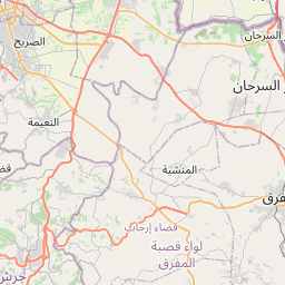
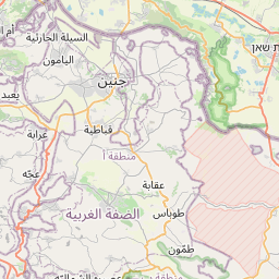

Major cities in the vicinity of Al-Hamra, Jordan
Irbid ... (31 Km)
Zarqa ... (43 Km)
Amman ... (59 Km)
Tiberias ... (70 Km)
Jenin ... (80 Km)
Afula ... (83 Km)
Nazareth ... (84 Km)
Safed ... (84 Km)
Nablus ... (87 Km)
Jericho ... (91 Km)
Karmiel ... (96 Km)
Kiryat Shmona ... (101 Km)
Ma'alot-Tarshiha ... (104 Km)
Kiryat Ata ... (105 Km)
Ramallah ... (108 Km)
East Jerusalem ... (114 Km)
Acre ... (114 Km)
Jerusalem ... (114 Km)
Hadera ... (115 Km)
Haifa ... (115 Km)
Nahariya ... (116 Km)
Nabatieh ... (120 Km)
Damascus ... (120 Km)
Bethlehem ... (121 Km)
Netanya ... (122 Km)
Modi'in-Maccabim-Re'ut ... (123 Km)
Herzliya ... (126 Km)
Tyre ... (128 Km)
Tel Aviv ... (134 Km)
Rishon LeZion ... (137 Km)
Note: The distance between two locations is provided as an aerial distance for informational purposes only. While approximate, this calculation is based on reliable data and may vary slightly from the actual distance as reported in official forecasts and advisories.


