Current Local Time in Ensenada, Baja California, Mexico
14:21:54
Saturday, 26 July 2025
| Country: | Mexico |
| State: | Baja California (BC) |
| Languages: | Spanish, Nahuatl, Yucatec Maya |
| Currency: | Mexican Peso (MXN) |
| Lat/Long: | 31.8667°N / 116.5964°W |
| Elevation: | 16 m |
| Country Code: | +52 |
Weather
°C
Change Units for Weather
Now

Partly Cloudy
24 °C
Sun, 27
Partly Cloudy
24 / 14 °C
Mon, 28
Partly Cloudy
25 / 15 °C
Tue, 29

Sunny
27 / 15 °C
Time Zone


DST started
9 Mar 2025 Forward 1 hour From 2:00 AM to 3:00 AM

DST ends
2 Nov 2025 Back 1 hour From 2:00 AM to 1:00 AM
Sun & Moon

Sunrise
05:58

Sunset
19:47

Day length
13 hours, 48 minutes -1m 17s shorter

Moon 2%
Rise - 07:50 Set - 21:20
Time Zone ConverterCompare the local time of two time zones, countries or cities of the world |  |
Ensenada
Time Difference to major World Cities
Upcoming Holidays
Tuesday, September 16, 2025 Independence Day
Monday, November 17, 2025 Revolution Day
Friday, December 12, 2025 Day of the Virgin of Guadalupe
Thursday, December 25, 2025 Christmas Day
Thursday, January 1, 2026 New Year's Day
Airports
Tijuana International Airport, TIJ About 83 km from Ensenada
Brown Field Municipal Airport, SDM About 86 km from Ensenada
North Island Naval Air Station-Halsey Field, NZY About 109 km from Ensenada
San Diego International Airport, SAN About 111 km from Ensenada
Miramar Marine Corps Air Station - Mitscher Field, NKX About 123 km from Ensenada
See on the Map
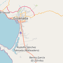


Major cities in the vicinity of Ensenada, Mexico
Tijuana ... (83 Km)
San Diego ... (108 Km)
Mexicali ... (137 Km)
Irvine ... (233 Km)
Anaheim ... (251 Km)
Long Beach ... (259 Km)
Los Angeles ... (288 Km)
Santa Monica ... (298 Km)
Santa Barbara ... (405 Km)
Bakersfield ... (450 Km)
Phoenix ... (458 Km)
Mesa ... (478 Km)
Prescott ... (486 Km)
Las Vegas ... (497 Km)
Tucson ... (532 Km)
Nogales ... (539 Km)
Flagstaff ... (589 Km)
Sierra Vista ... (599 Km)
Fresno ... (616 Km)
Hermosillo ... (623 Km)
St. George ... (644 Km)
Guaymas ... (702 Km)
Cedar City ... (722 Km)
Page ... (733 Km)
San Jose ... (777 Km)
Ciudad Obregón ... (807 Km)
Note: The distance between two locations is provided as an aerial distance for informational purposes only. While approximate, this calculation is based on reliable data and may vary slightly from the actual distance as reported in official forecasts and advisories.


