Current Local Time in Teror, Canary Islands, Spain
06:14:45
Friday, 25 July 2025
| Country: | Spain |
| Autonomous Community: | Canary Islands (CN) |
| Languages: | Spanish |
| Currency: | Euro (EUR) |
| Lat/Long: | 28.0616°N / 15.546°W |
| Elevation: | 543 m |
| Country Code: | +34 |
Weather
°C
Change Units for Weather
Now

Clear
22 °C
Sat, 26

Sunny
24 / 20 °C
Sun, 27
Sunny
26 / 21 °C
Mon, 28
Sunny
25 / 21 °C
Time Zone


DST started
30 Mar 2025 Forward 1 hour From 1:00 AM to 2:00 AM

DST ends
26 Oct 2025 Back 1 hour From 2:00 AM to 1:00 AM
Sun & Moon

Sunrise
07:21

Sunset
20:56

Day length
13 hours, 34 minutes -1m 5s shorter

Moon 0%
Rise - 07:50 Set - 21:47
Time Zone ConverterCompare the local time of two time zones, countries or cities of the world |  |
Teror
Time Difference to major World Cities
Upcoming Holidays
Friday, August 15, 2025 Assumption Day
Sunday, October 12, 2025 Hispanic Day
Monday, October 13, 2025 Hispanic Day observed
Saturday, November 1, 2025 All Saints' Day
Saturday, December 6, 2025 Constitution Day
Airports
Gran Canaria Airport, LPA About 21 km from Teror
Tenerife North–Ciudad de La Laguna Airport, TFN About 91 km from Teror
Tenerife Sur Airport, TFS About 101 km from Teror
Fuerteventura Airport, FUE About 170 km from Teror
César Manrique-Lanzarote Airport, ACE About 214 km from Teror
See on the Map
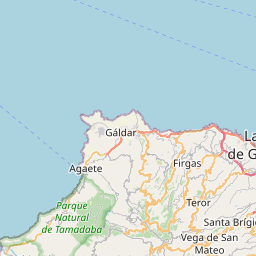
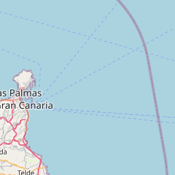


Major cities in the vicinity of Teror, Spain
Las Palmas ... (13 Km)
Santa Cruz de Tenerife ... (83 Km)
Puerto de la Cruz ... (105 Km)
Santa Cruz de La Palma ... (228 Km)
Laâyoune ... (252 Km)
Smara ... (410 Km)
Dakhla ... (484 Km)
Funchal ... (527 Km)
Sidi Ifni ... (544 Km)
Guelmim ... (546 Km)
Aousserd ... (627 Km)
Agadir ... (635 Km)
Zouérat ... (668 Km)
Essaouira ... (677 Km)
Bir Gandus ... (723 Km)
Tindouf ... (729 Km)
Safi ... (769 Km)
Nouadhibou ... (807 Km)
Note: The distance between two locations is provided as an aerial distance for informational purposes only. While approximate, this calculation is based on reliable data and may vary slightly from the actual distance as reported in official forecasts and advisories.


