Current Local Time in Rushville, Indiana, USA
19:51:10
Thursday, 24 July 2025
| Country: | United States |
| State: | Indiana (IN) |
| Languages: | English |
| Currency: | United States Dollar (USD) |
| Lat/Long: | 39.6092°N / 85.4464°W |
| Elevation: | 292 m |
| Country Code: | +1 |
Weather
°C
Change Units for Weather
Now

Sunny
32 °C
Fri, 25

Moderate rain
30 / 24 °C
Sat, 26

Patchy rain nearby
33 / 22 °C
Sun, 27

Heavy rain
31 / 23 °C
Time Zone


DST started
9 Mar 2025 Forward 1 hour From 2:00 AM to 3:00 AM

DST ends
2 Nov 2025 Back 1 hour From 2:00 AM to 1:00 AM
Sun & Moon

Sunrise
06:34

Sunset
21:01

Day length
14 hours, 26 minutes -1m 42s shorter

Moon 1%
Rise - 06:02 Set - 21:24
Time Zone ConverterCompare the local time of two time zones, countries or cities of the world |  |
Rushville
Time Difference to major World Cities
Upcoming Holidays
Monday, September 1, 2025 Labor Day
Monday, October 13, 2025 Columbus Day
Tuesday, November 4, 2025 Election Day
Tuesday, November 11, 2025 Veterans Day
Thursday, November 27, 2025 Thanksgiving Day
Airports
Columbus Municipal Airport, CLU About 55 km from Rushville
Delaware County Johnson Field, MIE About 71 km from Rushville
Indianapolis International Airport, IND About 74 km from Rushville
Cincinnati Northern Kentucky International Airport, CVG About 91 km from Rushville
Cincinnati Municipal Airport Lunken Field, LUK About 105 km from Rushville
See on the Map
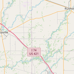

Major cities in the vicinity of Rushville, USA
Greenwood ... (57 Km)
Indianapolis ... (63 Km)
Muncie ... (65 Km)
Cincinnati ... (98 Km)
Bloomington ... (105 Km)
Dayton ... (109 Km)
Springfield ... (144 Km)
Lafayette ... (151 Km)
Louisville ... (153 Km)
Frankfort ... (164 Km)
Fort Wayne ... (166 Km)
Terre Haute ... (169 Km)
Lexington ... (193 Km)
Vincennes ... (207 Km)
Columbus ... (213 Km)
Elizabethtown ... (215 Km)
Richmond ... (230 Km)
South Bend ... (240 Km)
Champaign ... (245 Km)
Owensboro ... (250 Km)
Evansville ... (259 Km)
Kalamazoo ... (299 Km)
Bowling Green ... (305 Km)
Jackson ... (306 Km)
Chicago ... (312 Km)
Naperville ... (330 Km)
Ann Arbor ... (330 Km)
Lansing ... (355 Km)
Springfield ... (360 Km)
Detroit ... (364 Km)
Note: The distance between two locations is provided as an aerial distance for informational purposes only. While approximate, this calculation is based on reliable data and may vary slightly from the actual distance as reported in official forecasts and advisories.


